esmvaltool/ozone-lat-time/cmip6
Images
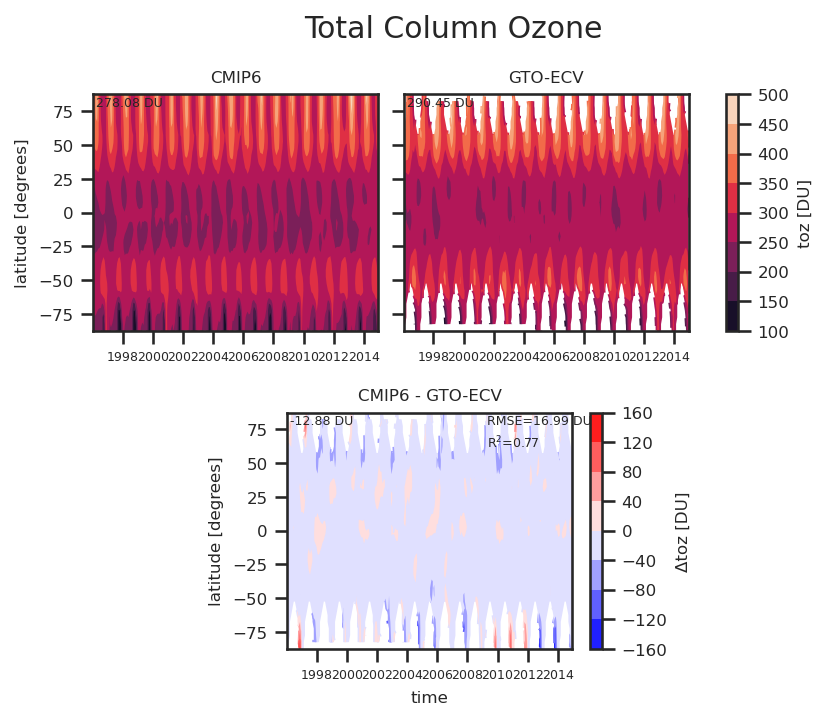
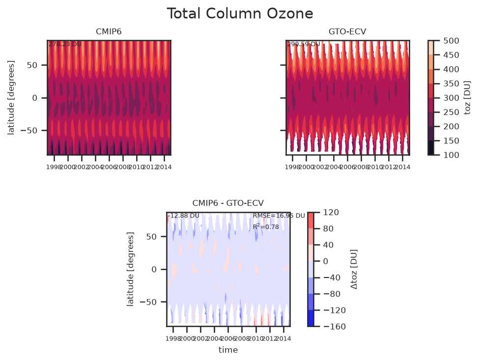
executions/recipe/plots/lat_time_mapplot/plot/hovmoeller_time_vs_lat_or_lon_toz_LatTime_Map.png
changed
147,681 B -> 143,815 B (-3,866)
old
new
Text
executions/recipe/run/lat_time_mapplot/plot/diagnostic_provenance.yml
changed
2,037 B -> 2,037 B (+0)
bebd2719f041 -> f0e73f1d0f96
old new
--- old+++ new@@ -1,7 +1,7 @@ ? <OUTPUT_DIR>/executions/recipe/plots/lat_time_mapplot/plot/hovmoeller_time_vs_lat_or_lon_toz_LatTime_Map.png : ancestors:- - <OUTPUT_DIR>/executions/recipe/preproc/lat_time_mapplot/toz/obs4MIPs_C3S-GTO-ECV-9-0_toz_1996-2014.nc- - <OUTPUT_DIR>/executions/recipe/preproc/lat_time_mapplot/toz/CMIP6_GFDL-ESM4_AERmon_historical_r1i1p1f1_toz_gr1_1996-2014.nc+ - <OUTPUT_DIR>/executions/recipe/preproc/lat_time_mapplot/toz/CMIP6_GFDL-ESM4_AERmon_historical_r1i1p1f1_toz_gr1_1997-2014.nc+ - <OUTPUT_DIR>/executions/recipe/preproc/lat_time_mapplot/toz/obs4MIPs_C3S-GTO-ECV-9-0_toz_1997-2014.nc authors: - schlund_manuel - kraft_jeremy@@ -14,8 +14,8 @@ - zonal ? <OUTPUT_DIR>/executions/recipe/work/lat_time_mapplot/plot/hovmoeller_time_vs_lat_or_lon_toz_LatTime_Map_bottom.nc : ancestors:- - <OUTPUT_DIR>/executions/recipe/preproc/lat_time_mapplot/toz/CMIP6_GFDL-ESM4_AERmon_historical_r1i1p1f1_toz_gr1_1996-2014.nc- - <OUTPUT_DIR>/executions/recipe/preproc/lat_time_mapplot/toz/obs4MIPs_C3S-GTO-ECV-9-0_toz_1996-2014.nc+ - <OUTPUT_DIR>/executions/recipe/preproc/lat_time_mapplot/toz/CMIP6_GFDL-ESM4_AERmon_historical_r1i1p1f1_toz_gr1_1997-2014.nc+ - <OUTPUT_DIR>/executions/recipe/preproc/lat_time_mapplot/toz/obs4MIPs_C3S-GTO-ECV-9-0_toz_1997-2014.nc authors: - schlund_manuel - kraft_jeremy@@ -27,7 +27,7 @@ - zonal ? <OUTPUT_DIR>/executions/recipe/work/lat_time_mapplot/plot/hovmoeller_time_vs_lat_or_lon_toz_LatTime_Map_top_left.nc : ancestors:- - <OUTPUT_DIR>/executions/recipe/preproc/lat_time_mapplot/toz/CMIP6_GFDL-ESM4_AERmon_historical_r1i1p1f1_toz_gr1_1996-2014.nc+ - <OUTPUT_DIR>/executions/recipe/preproc/lat_time_mapplot/toz/CMIP6_GFDL-ESM4_AERmon_historical_r1i1p1f1_toz_gr1_1997-2014.nc authors: - schlund_manuel - kraft_jeremy@@ -39,7 +39,7 @@ - zonal ? <OUTPUT_DIR>/executions/recipe/work/lat_time_mapplot/plot/hovmoeller_time_vs_lat_or_lon_toz_LatTime_Map_top_right.nc : ancestors:- - <OUTPUT_DIR>/executions/recipe/preproc/lat_time_mapplot/toz/obs4MIPs_C3S-GTO-ECV-9-0_toz_1996-2014.nc+ - <OUTPUT_DIR>/executions/recipe/preproc/lat_time_mapplot/toz/obs4MIPs_C3S-GTO-ECV-9-0_toz_1997-2014.nc authors: - schlund_manuel - kraft_jeremy
NetCDF
executions/recipe/work/lat_time_mapplot/plot/hovmoeller_time_vs_lat_or_lon_toz_LatTime_Map_bottom.nc
changed
64,540 B -> 62,598 B (-1,942)
old new
Header
xarray.Dataset { dimensions:- time = 228 ;+ time = 216 ; lat = 36 ; bnds = 2 ; variables: float32 bias_toz(time, lat) ; bias_toz:standard_name = equivalent_thickness_at_stp_of_atmosphere_ozone_content ; bias_toz:long_name = Bias in Total Column Ozone ; bias_toz:units = DU ;- bias_toz:filename = /tmp/ref-ozone-mint-ozone-lat-time/results/test-cases/esmvaltool/ozone-lat-time/cmip6/executions/recipe_20260713_133123/work/lat_time_mapplot/plot/hovmoeller_time_vs_lat_or_lon_toz_LatTime_Map_bottom.nc ;+ bias_toz:filename = /tmp/ref-ozone-3/results/test-cases/esmvaltool/ozone-lat-time/cmip6/executions/recipe_20260902_051046/work/lat_time_mapplot/plot/hovmoeller_time_vs_lat_or_lon_toz_LatTime_Map_bottom.nc ; bias_toz:interp_method = conserve_order1 ; bias_toz:original_name = toz ; bias_toz:cell_methods = area: time: mean longitude: mean ; bias_toz:coordinates = lon ; int64 time_bnds(time, bnds) ; float64 lat_bnds(lat, bnds) ; float64 lon() ; lon:bounds = lon_bnds ; lon:units = degrees_east ; lon:standard_name = longitude ; float64 lon_bnds(bnds) ; int64 time(time) ; time:axis = T ; time:bounds = time_bnds ; time:units = days since 1850-01-01 00:00:00 ; time:standard_name = time ; time:long_name = time ; time:calendar = standard ; float64 lat(lat) ; lat:axis = Y ; lat:bounds = lat_bnds ; lat:units = degrees_north ; lat:standard_name = latitude ; // global attributes: :Conventions = CF-1.7 ; :activity_id = CMIP ; :branch_method = standard ; :branch_time_in_child = 0.0 ; :branch_time_in_parent = -638385 ; :comment = <null ref> ; :contact = [email protected] ; :creation_date = 2019-08-06T03:37:45Z ; :data_specs_version = 01.00.27 ; :experiment = all-forcing simulation of the recent past ; :experiment_id = historical ; :external_variables = areacella ; :forcing_index = 1 ; :frequency = mon ; :further_info_url = https://furtherinfo.es-doc.org/CMIP6.NOAA-GFDL.GFDL-ESM4.historical.none.r1i1p1f1 ; :grid = atmos data regridded from Cubed-sphere (c96) to 180,288; interpolation method: conserve_order1 ; :grid_label = gr1 ; :history = File was processed by fremetar (GFDL analog of CMOR). TripleID: [exper_id_MFLg3OOf97,realiz_id_6UiFuoEKMa,run_id_PhuSv75why] ; :initialization_index = 1 ; :institution = National Oceanic and Atmospheric Administration, Geophysical Fluid Dynamics Laboratory, Princeton, NJ 08540, USA ; :institution_id = NOAA-GFDL ; :license = CMIP6 model data produced by NOAA-GFDL is licensed under a Creative Commons Attribution-ShareAlike 4.0 International License (https://creativecommons.org/licenses/). Consult https://pcmdi.llnl.gov/CMIP6/TermsOfUse for terms of use governing CMIP6 output, including citation requirements and proper acknowledgment. Further information about this data, including some limitations, can be found via the further_info_url (recorded as a global attribute in this file). The data producers and data providers make no warranty, either express or implied, including, but not limited to, warranties of merchantability and fitness for a particular purpose. All liabilities arising from the supply of the information (including any liability arising in negligence) are excluded to the fullest extent permitted by law. ; :mip_era = CMIP6 ; :nominal_resolution = 100 km ; :parent_activity_id = CMIP ; :parent_experiment_id = piControl ; :parent_mip_era = CMIP6 ; :parent_source_id = GFDL-ESM4 ; :parent_time_units = days since 1850-1-1 00:00:00 ; :parent_variant_label = r1i1p1f1 ; :physics_index = 1 ; :product = model-output ; :realization_index = 1 ; :realm = aerosol ; :references = see further_info_url attribute ;- :software = Created with ESMValTool v2.15.0.dev47+gd7569120c ;+ :software = Created with ESMValTool v2.15.0 ; :source = GFDL-ESM4 (2018): atmos: GFDL-AM4.1 (Cubed-sphere (c96) - 1 degree nominal horizontal resolution; 360 x 180 longitude/latitude; 49 levels; top level 1 Pa) ocean: GFDL-OM4p5 (GFDL-MOM6, tripolar - nominal 0.5 deg; 720 x 576 longitude/latitude; 75 levels; top grid cell 0-2 m) seaIce: GFDL-SIM4p5 (GFDL-SIS2.0, tripolar - nominal 0.5 deg; 720 x 576 longitude/latitude; 5 layers; 5 thickness categories) land: GFDL-LM4.1 aerosol: interactive atmosChem: GFDL-ATMCHEM4.1 (full atmospheric chemistry) ocnBgchem: GFDL-COBALTv2 landIce: GFDL-LM4.1 (GFDL ID: 2019_0353) ; :source_id = GFDL-ESM4 ; :source_type = AOGCM AER CHEM BGC ; :sub_experiment = none ; :sub_experiment_id = none ; :table_id = AERmon ; :title = NOAA GFDL GFDL-ESM4 model output prepared for CMIP6 all-forcing simulation of the recent past ; :tracking_id = hdl:21.14100/3e057662-232b-4bc1-8342-4db5beaec0c2 ; :variable_id = toz ; :variant_info = N/A ; :variant_label = r1i1p1f1 ; :caption = Hovmoeller plot of Total Column Ozone of dataset CMIP6 - GTO-ECV. ; }
old
xarray.Dataset {dimensions: time = 228 ; lat = 36 ; bnds = 2 ;variables: float32 bias_toz(time, lat) ; bias_toz:standard_name = equivalent_thickness_at_stp_of_atmosphere_ozone_content ; bias_toz:long_name = Bias in Total Column Ozone ; bias_toz:units = DU ; bias_toz:filename = /tmp/ref-ozone-mint-ozone-lat-time/results/test-cases/esmvaltool/ozone-lat-time/cmip6/executions/recipe_20260713_133123/work/lat_time_mapplot/plot/hovmoeller_time_vs_lat_or_lon_toz_LatTime_Map_bottom.nc ; bias_toz:interp_method = conserve_order1 ; bias_toz:original_name = toz ; bias_toz:cell_methods = area: time: mean longitude: mean ; bias_toz:coordinates = lon ; int64 time_bnds(time, bnds) ; float64 lat_bnds(lat, bnds) ; float64 lon() ; lon:bounds = lon_bnds ; lon:units = degrees_east ; lon:standard_name = longitude ; float64 lon_bnds(bnds) ; int64 time(time) ; time:axis = T ; time:bounds = time_bnds ; time:units = days since 1850-01-01 00:00:00 ; time:standard_name = time ; time:long_name = time ; time:calendar = standard ; float64 lat(lat) ; lat:axis = Y ; lat:bounds = lat_bnds ; lat:units = degrees_north ; lat:standard_name = latitude ;// global attributes: :Conventions = CF-1.7 ; :activity_id = CMIP ; :branch_method = standard ; :branch_time_in_child = 0.0 ; :branch_time_in_parent = -638385 ; :comment = <null ref> ; :contact = [email protected] ; :creation_date = 2019-08-06T03:37:45Z ; :data_specs_version = 01.00.27 ; :experiment = all-forcing simulation of the recent past ; :experiment_id = historical ; :external_variables = areacella ; :forcing_index = 1 ; :frequency = mon ; :further_info_url = https://furtherinfo.es-doc.org/CMIP6.NOAA-GFDL.GFDL-ESM4.historical.none.r1i1p1f1 ; :grid = atmos data regridded from Cubed-sphere (c96) to 180,288; interpolation method: conserve_order1 ; :grid_label = gr1 ; :history = File was processed by fremetar (GFDL analog of CMOR). TripleID: [exper_id_MFLg3OOf97,realiz_id_6UiFuoEKMa,run_id_PhuSv75why] ; :initialization_index = 1 ; :institution = National Oceanic and Atmospheric Administration, Geophysical Fluid Dynamics Laboratory, Princeton, NJ 08540, USA ; :institution_id = NOAA-GFDL ; :license = CMIP6 model data produced by NOAA-GFDL is licensed under a Creative Commons Attribution-ShareAlike 4.0 International License (https://creativecommons.org/licenses/). Consult https://pcmdi.llnl.gov/CMIP6/TermsOfUse for terms of use governing CMIP6 output, including citation requirements and proper acknowledgment. Further information about this data, including some limitations, can be found via the further_info_url (recorded as a global attribute in this file). The data producers and data providers make no warranty, either express or implied, including, but not limited to, warranties of merchantability and fitness for a particular purpose. All liabilities arising from the supply of the information (including any liability arising in negligence) are excluded to the fullest extent permitted by law. ; :mip_era = CMIP6 ; :nominal_resolution = 100 km ; :parent_activity_id = CMIP ; :parent_experiment_id = piControl ; :parent_mip_era = CMIP6 ; :parent_source_id = GFDL-ESM4 ; :parent_time_units = days since 1850-1-1 00:00:00 ; :parent_variant_label = r1i1p1f1 ; :physics_index = 1 ; :product = model-output ; :realization_index = 1 ; :realm = aerosol ; :references = see further_info_url attribute ; :software = Created with ESMValTool v2.15.0.dev47+gd7569120c ; :source = GFDL-ESM4 (2018):atmos: GFDL-AM4.1 (Cubed-sphere (c96) - 1 degree nominal horizontal resolution; 360 x 180 longitude/latitude; 49 levels; top level 1 Pa)ocean: GFDL-OM4p5 (GFDL-MOM6, tripolar - nominal 0.5 deg; 720 x 576 longitude/latitude; 75 levels; top grid cell 0-2 m)seaIce: GFDL-SIM4p5 (GFDL-SIS2.0, tripolar - nominal 0.5 deg; 720 x 576 longitude/latitude; 5 layers; 5 thickness categories)land: GFDL-LM4.1aerosol: interactiveatmosChem: GFDL-ATMCHEM4.1 (full atmospheric chemistry)ocnBgchem: GFDL-COBALTv2landIce: GFDL-LM4.1(GFDL ID: 2019_0353) ; :source_id = GFDL-ESM4 ; :source_type = AOGCM AER CHEM BGC ; :sub_experiment = none ; :sub_experiment_id = none ; :table_id = AERmon ; :title = NOAA GFDL GFDL-ESM4 model output prepared for CMIP6 all-forcing simulation of the recent past ; :tracking_id = hdl:21.14100/3e057662-232b-4bc1-8342-4db5beaec0c2 ; :variable_id = toz ; :variant_info = N/A ; :variant_label = r1i1p1f1 ; :caption = Hovmoeller plot of Total Column Ozone of dataset CMIP6 - GTO-ECV. ;}
new
xarray.Dataset {dimensions: time = 216 ; lat = 36 ; bnds = 2 ;variables: float32 bias_toz(time, lat) ; bias_toz:standard_name = equivalent_thickness_at_stp_of_atmosphere_ozone_content ; bias_toz:long_name = Bias in Total Column Ozone ; bias_toz:units = DU ; bias_toz:filename = /tmp/ref-ozone-3/results/test-cases/esmvaltool/ozone-lat-time/cmip6/executions/recipe_20260902_051046/work/lat_time_mapplot/plot/hovmoeller_time_vs_lat_or_lon_toz_LatTime_Map_bottom.nc ; bias_toz:interp_method = conserve_order1 ; bias_toz:original_name = toz ; bias_toz:cell_methods = area: time: mean longitude: mean ; bias_toz:coordinates = lon ; int64 time_bnds(time, bnds) ; float64 lat_bnds(lat, bnds) ; float64 lon() ; lon:bounds = lon_bnds ; lon:units = degrees_east ; lon:standard_name = longitude ; float64 lon_bnds(bnds) ; int64 time(time) ; time:axis = T ; time:bounds = time_bnds ; time:units = days since 1850-01-01 00:00:00 ; time:standard_name = time ; time:long_name = time ; time:calendar = standard ; float64 lat(lat) ; lat:axis = Y ; lat:bounds = lat_bnds ; lat:units = degrees_north ; lat:standard_name = latitude ;// global attributes: :Conventions = CF-1.7 ; :activity_id = CMIP ; :branch_method = standard ; :branch_time_in_child = 0.0 ; :branch_time_in_parent = -638385 ; :comment = <null ref> ; :contact = [email protected] ; :creation_date = 2019-08-06T03:37:45Z ; :data_specs_version = 01.00.27 ; :experiment = all-forcing simulation of the recent past ; :experiment_id = historical ; :external_variables = areacella ; :forcing_index = 1 ; :frequency = mon ; :further_info_url = https://furtherinfo.es-doc.org/CMIP6.NOAA-GFDL.GFDL-ESM4.historical.none.r1i1p1f1 ; :grid = atmos data regridded from Cubed-sphere (c96) to 180,288; interpolation method: conserve_order1 ; :grid_label = gr1 ; :history = File was processed by fremetar (GFDL analog of CMOR). TripleID: [exper_id_MFLg3OOf97,realiz_id_6UiFuoEKMa,run_id_PhuSv75why] ; :initialization_index = 1 ; :institution = National Oceanic and Atmospheric Administration, Geophysical Fluid Dynamics Laboratory, Princeton, NJ 08540, USA ; :institution_id = NOAA-GFDL ; :license = CMIP6 model data produced by NOAA-GFDL is licensed under a Creative Commons Attribution-ShareAlike 4.0 International License (https://creativecommons.org/licenses/). Consult https://pcmdi.llnl.gov/CMIP6/TermsOfUse for terms of use governing CMIP6 output, including citation requirements and proper acknowledgment. Further information about this data, including some limitations, can be found via the further_info_url (recorded as a global attribute in this file). The data producers and data providers make no warranty, either express or implied, including, but not limited to, warranties of merchantability and fitness for a particular purpose. All liabilities arising from the supply of the information (including any liability arising in negligence) are excluded to the fullest extent permitted by law. ; :mip_era = CMIP6 ; :nominal_resolution = 100 km ; :parent_activity_id = CMIP ; :parent_experiment_id = piControl ; :parent_mip_era = CMIP6 ; :parent_source_id = GFDL-ESM4 ; :parent_time_units = days since 1850-1-1 00:00:00 ; :parent_variant_label = r1i1p1f1 ; :physics_index = 1 ; :product = model-output ; :realization_index = 1 ; :realm = aerosol ; :references = see further_info_url attribute ; :software = Created with ESMValTool v2.15.0 ; :source = GFDL-ESM4 (2018):atmos: GFDL-AM4.1 (Cubed-sphere (c96) - 1 degree nominal horizontal resolution; 360 x 180 longitude/latitude; 49 levels; top level 1 Pa)ocean: GFDL-OM4p5 (GFDL-MOM6, tripolar - nominal 0.5 deg; 720 x 576 longitude/latitude; 75 levels; top grid cell 0-2 m)seaIce: GFDL-SIM4p5 (GFDL-SIS2.0, tripolar - nominal 0.5 deg; 720 x 576 longitude/latitude; 5 layers; 5 thickness categories)land: GFDL-LM4.1aerosol: interactiveatmosChem: GFDL-ATMCHEM4.1 (full atmospheric chemistry)ocnBgchem: GFDL-COBALTv2landIce: GFDL-LM4.1(GFDL ID: 2019_0353) ; :source_id = GFDL-ESM4 ; :source_type = AOGCM AER CHEM BGC ; :sub_experiment = none ; :sub_experiment_id = none ; :table_id = AERmon ; :title = NOAA GFDL GFDL-ESM4 model output prepared for CMIP6 all-forcing simulation of the recent past ; :tracking_id = hdl:21.14100/3e057662-232b-4bc1-8342-4db5beaec0c2 ; :variable_id = toz ; :variant_info = N/A ; :variant_label = r1i1p1f1 ; :caption = Hovmoeller plot of Total Column Ozone of dataset CMIP6 - GTO-ECV. ;}
| variable | shape | min | max | mean | nan | max abs diff | max rel diff | cells differ |
|---|---|---|---|---|---|---|---|---|
bias_toz |
228x36 -> 216x36 | -137.272 -> -137.272 | 9.96921e+36 -> 9.96921e+36 | 1.6166e+36 -> 1.61923e+36 | 0 -> 0 | - | - | - |
lat_bnds |
36x2 -> 36x2 | -90 -> -90 | 90 -> 90 | 0 -> 0 | 0 -> 0 | 0 | 0 | 0 |
lon |
scalar -> scalar | 180 -> 180 | 180 -> 180 | 180 -> 180 | 0 -> 0 | 0 | 0 | 0 |
lon_bnds |
2 -> 2 | 0 -> 0 | 360 -> 360 | 180 -> 180 | 0 -> 0 | 0 | 0 | 0 |
time_bnds |
228x2 -> 216x2 | 53325 -> 53691 | 60265 -> 60265 | 56794.6 -> 56977.2 | 0 -> 0 | - | - | - |
executions/recipe/work/lat_time_mapplot/plot/hovmoeller_time_vs_lat_or_lon_toz_LatTime_Map_top_left.nc
changed
64,725 B -> 62,414 B (-2,311)
old new
Header
xarray.Dataset { dimensions:- time = 228 ;+ time = 216 ; lat = 36 ; bnds = 2 ; variables: float32 toz(time, lat) ; toz:standard_name = equivalent_thickness_at_stp_of_atmosphere_ozone_content ; toz:long_name = Total Column Ozone ; toz:units = DU ;- toz:filename = /tmp/ref-ozone-mint-ozone-lat-time/results/test-cases/esmvaltool/ozone-lat-time/cmip6/executions/recipe_20260713_133123/work/lat_time_mapplot/plot/hovmoeller_time_vs_lat_or_lon_toz_LatTime_Map_top_left.nc ;+ toz:filename = /tmp/ref-ozone-3/results/test-cases/esmvaltool/ozone-lat-time/cmip6/executions/recipe_20260902_051046/work/lat_time_mapplot/plot/hovmoeller_time_vs_lat_or_lon_toz_LatTime_Map_top_left.nc ; toz:interp_method = conserve_order1 ; toz:original_name = toz ; toz:cell_methods = area: time: mean longitude: mean ; toz:coordinates = lon ; int64 time_bnds(time, bnds) ; float64 lat_bnds(lat, bnds) ; float64 lon() ; lon:bounds = lon_bnds ; lon:units = degrees_east ; lon:standard_name = longitude ; float64 lon_bnds(bnds) ; int64 time(time) ; time:axis = T ; time:bounds = time_bnds ; time:units = days since 1850-01-01 00:00:00 ; time:standard_name = time ; time:long_name = time ; time:calendar = standard ; float64 lat(lat) ; lat:axis = Y ; lat:bounds = lat_bnds ; lat:units = degrees_north ; lat:standard_name = latitude ; // global attributes: :Conventions = CF-1.7 ; :activity_id = CMIP ; :branch_method = standard ; :branch_time_in_child = 0.0 ; :branch_time_in_parent = -638385 ; :comment = <null ref> ; :contact = [email protected] ; :creation_date = 2019-08-06T03:37:45Z ; :data_specs_version = 01.00.27 ; :experiment = all-forcing simulation of the recent past ; :experiment_id = historical ; :external_variables = areacella ; :forcing_index = 1 ; :frequency = mon ; :further_info_url = https://furtherinfo.es-doc.org/CMIP6.NOAA-GFDL.GFDL-ESM4.historical.none.r1i1p1f1 ; :grid = atmos data regridded from Cubed-sphere (c96) to 180,288; interpolation method: conserve_order1 ; :grid_label = gr1 ; :history = File was processed by fremetar (GFDL analog of CMOR). TripleID: [exper_id_MFLg3OOf97,realiz_id_6UiFuoEKMa,run_id_PhuSv75why] ; :initialization_index = 1 ; :institution = National Oceanic and Atmospheric Administration, Geophysical Fluid Dynamics Laboratory, Princeton, NJ 08540, USA ; :institution_id = NOAA-GFDL ; :license = CMIP6 model data produced by NOAA-GFDL is licensed under a Creative Commons Attribution-ShareAlike 4.0 International License (https://creativecommons.org/licenses/). Consult https://pcmdi.llnl.gov/CMIP6/TermsOfUse for terms of use governing CMIP6 output, including citation requirements and proper acknowledgment. Further information about this data, including some limitations, can be found via the further_info_url (recorded as a global attribute in this file). The data producers and data providers make no warranty, either express or implied, including, but not limited to, warranties of merchantability and fitness for a particular purpose. All liabilities arising from the supply of the information (including any liability arising in negligence) are excluded to the fullest extent permitted by law. ; :mip_era = CMIP6 ; :nominal_resolution = 100 km ; :parent_activity_id = CMIP ; :parent_experiment_id = piControl ; :parent_mip_era = CMIP6 ; :parent_source_id = GFDL-ESM4 ; :parent_time_units = days since 1850-1-1 00:00:00 ; :parent_variant_label = r1i1p1f1 ; :physics_index = 1 ; :product = model-output ; :realization_index = 1 ; :realm = aerosol ; :references = see further_info_url attribute ;- :software = Created with ESMValTool v2.15.0.dev47+gd7569120c ;+ :software = Created with ESMValTool v2.15.0 ; :source = GFDL-ESM4 (2018): atmos: GFDL-AM4.1 (Cubed-sphere (c96) - 1 degree nominal horizontal resolution; 360 x 180 longitude/latitude; 49 levels; top level 1 Pa) ocean: GFDL-OM4p5 (GFDL-MOM6, tripolar - nominal 0.5 deg; 720 x 576 longitude/latitude; 75 levels; top grid cell 0-2 m) seaIce: GFDL-SIM4p5 (GFDL-SIS2.0, tripolar - nominal 0.5 deg; 720 x 576 longitude/latitude; 5 layers; 5 thickness categories) land: GFDL-LM4.1 aerosol: interactive atmosChem: GFDL-ATMCHEM4.1 (full atmospheric chemistry) ocnBgchem: GFDL-COBALTv2 landIce: GFDL-LM4.1 (GFDL ID: 2019_0353) ; :source_id = GFDL-ESM4 ; :source_type = AOGCM AER CHEM BGC ; :sub_experiment = none ; :sub_experiment_id = none ; :table_id = AERmon ; :title = NOAA GFDL GFDL-ESM4 model output prepared for CMIP6 all-forcing simulation of the recent past ; :tracking_id = hdl:21.14100/3e057662-232b-4bc1-8342-4db5beaec0c2 ; :variable_id = toz ; :variant_info = N/A ; :variant_label = r1i1p1f1 ; :caption = Hovmoeller plot of Total Column Ozone of dataset CMIP6. ; }
old
xarray.Dataset {dimensions: time = 228 ; lat = 36 ; bnds = 2 ;variables: float32 toz(time, lat) ; toz:standard_name = equivalent_thickness_at_stp_of_atmosphere_ozone_content ; toz:long_name = Total Column Ozone ; toz:units = DU ; toz:filename = /tmp/ref-ozone-mint-ozone-lat-time/results/test-cases/esmvaltool/ozone-lat-time/cmip6/executions/recipe_20260713_133123/work/lat_time_mapplot/plot/hovmoeller_time_vs_lat_or_lon_toz_LatTime_Map_top_left.nc ; toz:interp_method = conserve_order1 ; toz:original_name = toz ; toz:cell_methods = area: time: mean longitude: mean ; toz:coordinates = lon ; int64 time_bnds(time, bnds) ; float64 lat_bnds(lat, bnds) ; float64 lon() ; lon:bounds = lon_bnds ; lon:units = degrees_east ; lon:standard_name = longitude ; float64 lon_bnds(bnds) ; int64 time(time) ; time:axis = T ; time:bounds = time_bnds ; time:units = days since 1850-01-01 00:00:00 ; time:standard_name = time ; time:long_name = time ; time:calendar = standard ; float64 lat(lat) ; lat:axis = Y ; lat:bounds = lat_bnds ; lat:units = degrees_north ; lat:standard_name = latitude ;// global attributes: :Conventions = CF-1.7 ; :activity_id = CMIP ; :branch_method = standard ; :branch_time_in_child = 0.0 ; :branch_time_in_parent = -638385 ; :comment = <null ref> ; :contact = [email protected] ; :creation_date = 2019-08-06T03:37:45Z ; :data_specs_version = 01.00.27 ; :experiment = all-forcing simulation of the recent past ; :experiment_id = historical ; :external_variables = areacella ; :forcing_index = 1 ; :frequency = mon ; :further_info_url = https://furtherinfo.es-doc.org/CMIP6.NOAA-GFDL.GFDL-ESM4.historical.none.r1i1p1f1 ; :grid = atmos data regridded from Cubed-sphere (c96) to 180,288; interpolation method: conserve_order1 ; :grid_label = gr1 ; :history = File was processed by fremetar (GFDL analog of CMOR). TripleID: [exper_id_MFLg3OOf97,realiz_id_6UiFuoEKMa,run_id_PhuSv75why] ; :initialization_index = 1 ; :institution = National Oceanic and Atmospheric Administration, Geophysical Fluid Dynamics Laboratory, Princeton, NJ 08540, USA ; :institution_id = NOAA-GFDL ; :license = CMIP6 model data produced by NOAA-GFDL is licensed under a Creative Commons Attribution-ShareAlike 4.0 International License (https://creativecommons.org/licenses/). Consult https://pcmdi.llnl.gov/CMIP6/TermsOfUse for terms of use governing CMIP6 output, including citation requirements and proper acknowledgment. Further information about this data, including some limitations, can be found via the further_info_url (recorded as a global attribute in this file). The data producers and data providers make no warranty, either express or implied, including, but not limited to, warranties of merchantability and fitness for a particular purpose. All liabilities arising from the supply of the information (including any liability arising in negligence) are excluded to the fullest extent permitted by law. ; :mip_era = CMIP6 ; :nominal_resolution = 100 km ; :parent_activity_id = CMIP ; :parent_experiment_id = piControl ; :parent_mip_era = CMIP6 ; :parent_source_id = GFDL-ESM4 ; :parent_time_units = days since 1850-1-1 00:00:00 ; :parent_variant_label = r1i1p1f1 ; :physics_index = 1 ; :product = model-output ; :realization_index = 1 ; :realm = aerosol ; :references = see further_info_url attribute ; :software = Created with ESMValTool v2.15.0.dev47+gd7569120c ; :source = GFDL-ESM4 (2018):atmos: GFDL-AM4.1 (Cubed-sphere (c96) - 1 degree nominal horizontal resolution; 360 x 180 longitude/latitude; 49 levels; top level 1 Pa)ocean: GFDL-OM4p5 (GFDL-MOM6, tripolar - nominal 0.5 deg; 720 x 576 longitude/latitude; 75 levels; top grid cell 0-2 m)seaIce: GFDL-SIM4p5 (GFDL-SIS2.0, tripolar - nominal 0.5 deg; 720 x 576 longitude/latitude; 5 layers; 5 thickness categories)land: GFDL-LM4.1aerosol: interactiveatmosChem: GFDL-ATMCHEM4.1 (full atmospheric chemistry)ocnBgchem: GFDL-COBALTv2landIce: GFDL-LM4.1(GFDL ID: 2019_0353) ; :source_id = GFDL-ESM4 ; :source_type = AOGCM AER CHEM BGC ; :sub_experiment = none ; :sub_experiment_id = none ; :table_id = AERmon ; :title = NOAA GFDL GFDL-ESM4 model output prepared for CMIP6 all-forcing simulation of the recent past ; :tracking_id = hdl:21.14100/3e057662-232b-4bc1-8342-4db5beaec0c2 ; :variable_id = toz ; :variant_info = N/A ; :variant_label = r1i1p1f1 ; :caption = Hovmoeller plot of Total Column Ozone of dataset CMIP6. ;}
new
xarray.Dataset {dimensions: time = 216 ; lat = 36 ; bnds = 2 ;variables: float32 toz(time, lat) ; toz:standard_name = equivalent_thickness_at_stp_of_atmosphere_ozone_content ; toz:long_name = Total Column Ozone ; toz:units = DU ; toz:filename = /tmp/ref-ozone-3/results/test-cases/esmvaltool/ozone-lat-time/cmip6/executions/recipe_20260902_051046/work/lat_time_mapplot/plot/hovmoeller_time_vs_lat_or_lon_toz_LatTime_Map_top_left.nc ; toz:interp_method = conserve_order1 ; toz:original_name = toz ; toz:cell_methods = area: time: mean longitude: mean ; toz:coordinates = lon ; int64 time_bnds(time, bnds) ; float64 lat_bnds(lat, bnds) ; float64 lon() ; lon:bounds = lon_bnds ; lon:units = degrees_east ; lon:standard_name = longitude ; float64 lon_bnds(bnds) ; int64 time(time) ; time:axis = T ; time:bounds = time_bnds ; time:units = days since 1850-01-01 00:00:00 ; time:standard_name = time ; time:long_name = time ; time:calendar = standard ; float64 lat(lat) ; lat:axis = Y ; lat:bounds = lat_bnds ; lat:units = degrees_north ; lat:standard_name = latitude ;// global attributes: :Conventions = CF-1.7 ; :activity_id = CMIP ; :branch_method = standard ; :branch_time_in_child = 0.0 ; :branch_time_in_parent = -638385 ; :comment = <null ref> ; :contact = [email protected] ; :creation_date = 2019-08-06T03:37:45Z ; :data_specs_version = 01.00.27 ; :experiment = all-forcing simulation of the recent past ; :experiment_id = historical ; :external_variables = areacella ; :forcing_index = 1 ; :frequency = mon ; :further_info_url = https://furtherinfo.es-doc.org/CMIP6.NOAA-GFDL.GFDL-ESM4.historical.none.r1i1p1f1 ; :grid = atmos data regridded from Cubed-sphere (c96) to 180,288; interpolation method: conserve_order1 ; :grid_label = gr1 ; :history = File was processed by fremetar (GFDL analog of CMOR). TripleID: [exper_id_MFLg3OOf97,realiz_id_6UiFuoEKMa,run_id_PhuSv75why] ; :initialization_index = 1 ; :institution = National Oceanic and Atmospheric Administration, Geophysical Fluid Dynamics Laboratory, Princeton, NJ 08540, USA ; :institution_id = NOAA-GFDL ; :license = CMIP6 model data produced by NOAA-GFDL is licensed under a Creative Commons Attribution-ShareAlike 4.0 International License (https://creativecommons.org/licenses/). Consult https://pcmdi.llnl.gov/CMIP6/TermsOfUse for terms of use governing CMIP6 output, including citation requirements and proper acknowledgment. Further information about this data, including some limitations, can be found via the further_info_url (recorded as a global attribute in this file). The data producers and data providers make no warranty, either express or implied, including, but not limited to, warranties of merchantability and fitness for a particular purpose. All liabilities arising from the supply of the information (including any liability arising in negligence) are excluded to the fullest extent permitted by law. ; :mip_era = CMIP6 ; :nominal_resolution = 100 km ; :parent_activity_id = CMIP ; :parent_experiment_id = piControl ; :parent_mip_era = CMIP6 ; :parent_source_id = GFDL-ESM4 ; :parent_time_units = days since 1850-1-1 00:00:00 ; :parent_variant_label = r1i1p1f1 ; :physics_index = 1 ; :product = model-output ; :realization_index = 1 ; :realm = aerosol ; :references = see further_info_url attribute ; :software = Created with ESMValTool v2.15.0 ; :source = GFDL-ESM4 (2018):atmos: GFDL-AM4.1 (Cubed-sphere (c96) - 1 degree nominal horizontal resolution; 360 x 180 longitude/latitude; 49 levels; top level 1 Pa)ocean: GFDL-OM4p5 (GFDL-MOM6, tripolar - nominal 0.5 deg; 720 x 576 longitude/latitude; 75 levels; top grid cell 0-2 m)seaIce: GFDL-SIM4p5 (GFDL-SIS2.0, tripolar - nominal 0.5 deg; 720 x 576 longitude/latitude; 5 layers; 5 thickness categories)land: GFDL-LM4.1aerosol: interactiveatmosChem: GFDL-ATMCHEM4.1 (full atmospheric chemistry)ocnBgchem: GFDL-COBALTv2landIce: GFDL-LM4.1(GFDL ID: 2019_0353) ; :source_id = GFDL-ESM4 ; :source_type = AOGCM AER CHEM BGC ; :sub_experiment = none ; :sub_experiment_id = none ; :table_id = AERmon ; :title = NOAA GFDL GFDL-ESM4 model output prepared for CMIP6 all-forcing simulation of the recent past ; :tracking_id = hdl:21.14100/3e057662-232b-4bc1-8342-4db5beaec0c2 ; :variable_id = toz ; :variant_info = N/A ; :variant_label = r1i1p1f1 ; :caption = Hovmoeller plot of Total Column Ozone of dataset CMIP6. ;}
| variable | shape | min | max | mean | nan | max abs diff | max rel diff | cells differ |
|---|---|---|---|---|---|---|---|---|
lat_bnds |
36x2 -> 36x2 | -90 -> -90 | 90 -> 90 | 0 -> 0 | 0 -> 0 | 0 | 0 | 0 |
lon |
scalar -> scalar | 180 -> 180 | 180 -> 180 | 180 -> 180 | 0 -> 0 | 0 | 0 | 0 |
lon_bnds |
2 -> 2 | 0 -> 0 | 360 -> 360 | 180 -> 180 | 0 -> 0 | 0 | 0 | 0 |
time_bnds |
228x2 -> 216x2 | 53325 -> 53691 | 60265 -> 60265 | 56794.6 -> 56977.2 | 0 -> 0 | - | - | - |
toz |
228x36 -> 216x36 | 103.452 -> 103.452 | 474.984 -> 474.984 | 284.205 -> 284.333 | 0 -> 0 | - | - | - |
executions/recipe/work/lat_time_mapplot/plot/hovmoeller_time_vs_lat_or_lon_toz_LatTime_Map_top_right.nc
changed
63,332 B -> 61,096 B (-2,236)
old new
Header
xarray.Dataset { dimensions:- time = 228 ;+ time = 216 ; lat = 36 ; bnds = 2 ; variables: float32 toz(time, lat) ; toz:standard_name = equivalent_thickness_at_stp_of_atmosphere_ozone_content ; toz:long_name = Total Ozone Column ; toz:units = DU ; toz:comment = Total ozone column calculated at 0 degrees C and 1 bar, such that 1m = 1e5 DU. ;- toz:filename = /tmp/ref-ozone-mint-ozone-lat-time/results/test-cases/esmvaltool/ozone-lat-time/cmip6/executions/recipe_20260713_133123/work/lat_time_mapplot/plot/hovmoeller_time_vs_lat_or_lon_toz_LatTime_Map_top_right.nc ;+ toz:filename = /tmp/ref-ozone-3/results/test-cases/esmvaltool/ozone-lat-time/cmip6/executions/recipe_20260902_051046/work/lat_time_mapplot/plot/hovmoeller_time_vs_lat_or_lon_toz_LatTime_Map_top_right.nc ; toz:cell_methods = area: time: mean longitude: mean ; toz:coordinates = lon ; int64 time_bnds(time, bnds) ; float64 lat_bnds(lat, bnds) ; float64 lon() ; lon:bounds = lon_bnds ; lon:units = degrees_east ; lon:standard_name = longitude ; float64 lon_bnds(bnds) ; int64 time(time) ; time:axis = T ; time:bounds = time_bnds ; time:units = days since 1850-01-01 00:00:00 ; time:standard_name = time ; time:long_name = time ; time:calendar = standard ; float64 lat(lat) ; lat:axis = Y ; lat:bounds = lat_bnds ; lat:units = degrees_north ; lat:standard_name = latitude ; // global attributes: :Conventions = CF-1.7 ; :activity_id = obs4MIPs ; :cmor_version = 3.6.1 ; :comment = The data were generated at DLR as part of the ECMWF C3S2_312a_Lot2 project for the Copernicus Climate Change Service (C3S), and were produced using algorithms developed in the framework of the European Space Agency's Climate Change Initiative (ESA CCI). They were reformatted into Obs4MIPs format by the CCI CMUG project. ; :contact = [email protected] ; :creation_date = 2023-11-15T16:45:19Z ; :data_specs_version = 2.1.0 ; :external_variables = areacella ; :frequency = mon ; :further_info_url = https://furtherinfo.es-doc.org/obs4MIPs.DLR-BIRA.C3S-GTO-ECV.C3S-GTO-ECV-9-0.toz ; :grid = data gridded to 1x1 degree lat x lon ; :grid_label = gn ; :history = 2023-11-15T16:45:19Z; CMOR rewrote data to be consistent with obs4MIPs, and CF-1.7 ODS-2.1 standards ; :institution = Deutsches Zentrum fur Luft- und Raumfahrt, Royal Belgian Institute for Space Aeronomy ; :institution_id = DLR-BIRA ; :license = Data in this file produced by DLR is licensed under a DLR CC BY-NC-ND 3.0 licence (https://www.dlr.de/en/service/imprint). Use of the data must be acknowledged. Further information about this data, including some limitations, can be found via https://atmos.eoc.dlr.de/app/products/gto-ecv. ; :mip_era = CMIP6 ; :nominal_resolution = 1x1 degree ; :originData_URL = https://doi.org/10.24381/cds.4ebfe4eb ; :originData_notes = Data selection from C3S CDS:'processing_level': 'level_3', 'variable': 'atmosphere_mole_content_of_ozone','vertical_aggregation': 'total_column', 'sensor': 'merged_uv', 'version': ['v0100','v0900'] ; :originData_retrieved = 20230123; AMW@CEDA ; :product = observations ; :realm = atmos ; :references = GTO-ECV reference: Coldewey-Egbers et al., The GOME-type Total Ozone Essential Climate Variable (GTO-ECV) data record from the ESA Climate Change Initiative, Atmos. Meas.Tech., 8, 3923-3940, 2015. https://amt.copernicus.org/articles/8/3923/2015/amt-8-3923-2015.pdf ; :region = global ; :release_year = 2023 ;- :software = Created with ESMValTool v2.15.0.dev47+gd7569120c ;+ :software = Created with ESMValTool v2.15.0 ; :source = GOME-type Total Ozone Essential Climate Variable (GTO-ECV), generated by combining measurements from several nadir-viewing satellite sensors (GOME/ERS-2, SCIAMACHY/Envisat, OMI/Aura, GOME-2/MetOp-A, GOME-2/MetOp-B, GOME-2/MetOp-C, and TROPOMI/Sentinel-5p ; :source_description = GOME-type Total Ozone Essential Climate Variable (GTO-ECV), generated by combining measurements from several nadir-viewing satellite sensors (GOME/ERS-2, SCIAMACHY/Envisat, OMI/Aura, GOME-2/MetOp-A, GOME-2/MetOp-B, GOME-2/MetOp-C, and TROPOMI/Sentinel-5p ; :source_id = C3S-GTO-ECV-9-0 ; :source_label = C3S-GTO-ECV ; :source_name = C3S-GTO-ECV ; :source_type = satellite_retrieval ; :source_version_number = 9.0 ; :table_id = obs4MIPs_Amon ; :table_info = Creation Date:(18 November 2020) MD5:84743863b923e5eaa402e395fcf00e9f ; :title = L3 total ozone satellite observations v9.0 ; :tracking_id = hdl:21.14102/1202cf69-e0ae-4c67-9ad9-7c57c7f4e2cf ; :variable_id = toz ; :variant_info = Best Estimate ; :variant_label = BE ; :caption = Hovmoeller plot of Total Ozone Column of dataset GTO-ECV. ; }
old
xarray.Dataset {dimensions: time = 228 ; lat = 36 ; bnds = 2 ;variables: float32 toz(time, lat) ; toz:standard_name = equivalent_thickness_at_stp_of_atmosphere_ozone_content ; toz:long_name = Total Ozone Column ; toz:units = DU ; toz:comment = Total ozone column calculated at 0 degrees C and 1 bar, such that 1m = 1e5 DU. ; toz:filename = /tmp/ref-ozone-mint-ozone-lat-time/results/test-cases/esmvaltool/ozone-lat-time/cmip6/executions/recipe_20260713_133123/work/lat_time_mapplot/plot/hovmoeller_time_vs_lat_or_lon_toz_LatTime_Map_top_right.nc ; toz:cell_methods = area: time: mean longitude: mean ; toz:coordinates = lon ; int64 time_bnds(time, bnds) ; float64 lat_bnds(lat, bnds) ; float64 lon() ; lon:bounds = lon_bnds ; lon:units = degrees_east ; lon:standard_name = longitude ; float64 lon_bnds(bnds) ; int64 time(time) ; time:axis = T ; time:bounds = time_bnds ; time:units = days since 1850-01-01 00:00:00 ; time:standard_name = time ; time:long_name = time ; time:calendar = standard ; float64 lat(lat) ; lat:axis = Y ; lat:bounds = lat_bnds ; lat:units = degrees_north ; lat:standard_name = latitude ;// global attributes: :Conventions = CF-1.7 ; :activity_id = obs4MIPs ; :cmor_version = 3.6.1 ; :comment = The data were generated at DLR as part of the ECMWF C3S2_312a_Lot2 project for the Copernicus Climate Change Service (C3S), and were produced using algorithms developed in the framework of the European Space Agency's Climate Change Initiative (ESA CCI). They were reformatted into Obs4MIPs format by the CCI CMUG project. ; :contact = [email protected] ; :creation_date = 2023-11-15T16:45:19Z ; :data_specs_version = 2.1.0 ; :external_variables = areacella ; :frequency = mon ; :further_info_url = https://furtherinfo.es-doc.org/obs4MIPs.DLR-BIRA.C3S-GTO-ECV.C3S-GTO-ECV-9-0.toz ; :grid = data gridded to 1x1 degree lat x lon ; :grid_label = gn ; :history = 2023-11-15T16:45:19Z; CMOR rewrote data to be consistent with obs4MIPs, and CF-1.7 ODS-2.1 standards ; :institution = Deutsches Zentrum fur Luft- und Raumfahrt, Royal Belgian Institute for Space Aeronomy ; :institution_id = DLR-BIRA ; :license = Data in this file produced by DLR is licensed under a DLR CC BY-NC-ND 3.0 licence (https://www.dlr.de/en/service/imprint). Use of the data must be acknowledged. Further information about this data, including some limitations, can be found via https://atmos.eoc.dlr.de/app/products/gto-ecv. ; :mip_era = CMIP6 ; :nominal_resolution = 1x1 degree ; :originData_URL = https://doi.org/10.24381/cds.4ebfe4eb ; :originData_notes = Data selection from C3S CDS:'processing_level': 'level_3', 'variable': 'atmosphere_mole_content_of_ozone','vertical_aggregation': 'total_column', 'sensor': 'merged_uv', 'version': ['v0100','v0900'] ; :originData_retrieved = 20230123; AMW@CEDA ; :product = observations ; :realm = atmos ; :references = GTO-ECV reference: Coldewey-Egbers et al., The GOME-type Total Ozone Essential Climate Variable (GTO-ECV) data record from the ESA Climate Change Initiative, Atmos. Meas.Tech., 8, 3923-3940, 2015. https://amt.copernicus.org/articles/8/3923/2015/amt-8-3923-2015.pdf ; :region = global ; :release_year = 2023 ; :software = Created with ESMValTool v2.15.0.dev47+gd7569120c ; :source = GOME-type Total Ozone Essential Climate Variable (GTO-ECV), generated by combining measurements from several nadir-viewing satellite sensors (GOME/ERS-2, SCIAMACHY/Envisat, OMI/Aura, GOME-2/MetOp-A, GOME-2/MetOp-B, GOME-2/MetOp-C, and TROPOMI/Sentinel-5p ; :source_description = GOME-type Total Ozone Essential Climate Variable (GTO-ECV), generated by combining measurements from several nadir-viewing satellite sensors (GOME/ERS-2, SCIAMACHY/Envisat, OMI/Aura, GOME-2/MetOp-A, GOME-2/MetOp-B, GOME-2/MetOp-C, and TROPOMI/Sentinel-5p ; :source_id = C3S-GTO-ECV-9-0 ; :source_label = C3S-GTO-ECV ; :source_name = C3S-GTO-ECV ; :source_type = satellite_retrieval ; :source_version_number = 9.0 ; :table_id = obs4MIPs_Amon ; :table_info = Creation Date:(18 November 2020) MD5:84743863b923e5eaa402e395fcf00e9f ; :title = L3 total ozone satellite observations v9.0 ; :tracking_id = hdl:21.14102/1202cf69-e0ae-4c67-9ad9-7c57c7f4e2cf ; :variable_id = toz ; :variant_info = Best Estimate ; :variant_label = BE ; :caption = Hovmoeller plot of Total Ozone Column of dataset GTO-ECV. ;}
new
xarray.Dataset {dimensions: time = 216 ; lat = 36 ; bnds = 2 ;variables: float32 toz(time, lat) ; toz:standard_name = equivalent_thickness_at_stp_of_atmosphere_ozone_content ; toz:long_name = Total Ozone Column ; toz:units = DU ; toz:comment = Total ozone column calculated at 0 degrees C and 1 bar, such that 1m = 1e5 DU. ; toz:filename = /tmp/ref-ozone-3/results/test-cases/esmvaltool/ozone-lat-time/cmip6/executions/recipe_20260902_051046/work/lat_time_mapplot/plot/hovmoeller_time_vs_lat_or_lon_toz_LatTime_Map_top_right.nc ; toz:cell_methods = area: time: mean longitude: mean ; toz:coordinates = lon ; int64 time_bnds(time, bnds) ; float64 lat_bnds(lat, bnds) ; float64 lon() ; lon:bounds = lon_bnds ; lon:units = degrees_east ; lon:standard_name = longitude ; float64 lon_bnds(bnds) ; int64 time(time) ; time:axis = T ; time:bounds = time_bnds ; time:units = days since 1850-01-01 00:00:00 ; time:standard_name = time ; time:long_name = time ; time:calendar = standard ; float64 lat(lat) ; lat:axis = Y ; lat:bounds = lat_bnds ; lat:units = degrees_north ; lat:standard_name = latitude ;// global attributes: :Conventions = CF-1.7 ; :activity_id = obs4MIPs ; :cmor_version = 3.6.1 ; :comment = The data were generated at DLR as part of the ECMWF C3S2_312a_Lot2 project for the Copernicus Climate Change Service (C3S), and were produced using algorithms developed in the framework of the European Space Agency's Climate Change Initiative (ESA CCI). They were reformatted into Obs4MIPs format by the CCI CMUG project. ; :contact = [email protected] ; :creation_date = 2023-11-15T16:45:19Z ; :data_specs_version = 2.1.0 ; :external_variables = areacella ; :frequency = mon ; :further_info_url = https://furtherinfo.es-doc.org/obs4MIPs.DLR-BIRA.C3S-GTO-ECV.C3S-GTO-ECV-9-0.toz ; :grid = data gridded to 1x1 degree lat x lon ; :grid_label = gn ; :history = 2023-11-15T16:45:19Z; CMOR rewrote data to be consistent with obs4MIPs, and CF-1.7 ODS-2.1 standards ; :institution = Deutsches Zentrum fur Luft- und Raumfahrt, Royal Belgian Institute for Space Aeronomy ; :institution_id = DLR-BIRA ; :license = Data in this file produced by DLR is licensed under a DLR CC BY-NC-ND 3.0 licence (https://www.dlr.de/en/service/imprint). Use of the data must be acknowledged. Further information about this data, including some limitations, can be found via https://atmos.eoc.dlr.de/app/products/gto-ecv. ; :mip_era = CMIP6 ; :nominal_resolution = 1x1 degree ; :originData_URL = https://doi.org/10.24381/cds.4ebfe4eb ; :originData_notes = Data selection from C3S CDS:'processing_level': 'level_3', 'variable': 'atmosphere_mole_content_of_ozone','vertical_aggregation': 'total_column', 'sensor': 'merged_uv', 'version': ['v0100','v0900'] ; :originData_retrieved = 20230123; AMW@CEDA ; :product = observations ; :realm = atmos ; :references = GTO-ECV reference: Coldewey-Egbers et al., The GOME-type Total Ozone Essential Climate Variable (GTO-ECV) data record from the ESA Climate Change Initiative, Atmos. Meas.Tech., 8, 3923-3940, 2015. https://amt.copernicus.org/articles/8/3923/2015/amt-8-3923-2015.pdf ; :region = global ; :release_year = 2023 ; :software = Created with ESMValTool v2.15.0 ; :source = GOME-type Total Ozone Essential Climate Variable (GTO-ECV), generated by combining measurements from several nadir-viewing satellite sensors (GOME/ERS-2, SCIAMACHY/Envisat, OMI/Aura, GOME-2/MetOp-A, GOME-2/MetOp-B, GOME-2/MetOp-C, and TROPOMI/Sentinel-5p ; :source_description = GOME-type Total Ozone Essential Climate Variable (GTO-ECV), generated by combining measurements from several nadir-viewing satellite sensors (GOME/ERS-2, SCIAMACHY/Envisat, OMI/Aura, GOME-2/MetOp-A, GOME-2/MetOp-B, GOME-2/MetOp-C, and TROPOMI/Sentinel-5p ; :source_id = C3S-GTO-ECV-9-0 ; :source_label = C3S-GTO-ECV ; :source_name = C3S-GTO-ECV ; :source_type = satellite_retrieval ; :source_version_number = 9.0 ; :table_id = obs4MIPs_Amon ; :table_info = Creation Date:(18 November 2020) MD5:84743863b923e5eaa402e395fcf00e9f ; :title = L3 total ozone satellite observations v9.0 ; :tracking_id = hdl:21.14102/1202cf69-e0ae-4c67-9ad9-7c57c7f4e2cf ; :variable_id = toz ; :variant_info = Best Estimate ; :variant_label = BE ; :caption = Hovmoeller plot of Total Ozone Column of dataset GTO-ECV. ;}
| variable | shape | min | max | mean | nan | max abs diff | max rel diff | cells differ |
|---|---|---|---|---|---|---|---|---|
lat_bnds |
36x2 -> 36x2 | -90 -> -90 | 90 -> 90 | 0 -> 0 | 0 -> 0 | 0 | 0 | 0 |
lon |
scalar -> scalar | 180 -> 180 | 180 -> 180 | 180 -> 180 | 0 -> 0 | 0 | 0 | 0 |
lon_bnds |
2 -> 2 | 0 -> 0 | 360 -> 360 | 180 -> 180 | 0 -> 0 | 0 | 0 | 0 |
time_bnds |
228x2 -> 216x2 | 53325 -> 53691 | 60265 -> 60265 | 56794.6 -> 56977.2 | 0 -> 0 | - | - | - |
toz |
228x36 -> 216x36 | 137.368 -> 137.368 | 9.96921e+36 -> 9.96921e+36 | 1.6166e+36 -> 1.61923e+36 | 0 -> 0 | - | - | - |